River Conditions + Hazards
The Upper Delaware
Although the Upper Delaware is known for its whitewater and draws heavy traffic during warm weather months, the first 30 miles below Hancock feature a series of shallow riffles and pools. Upstream reservoir releases produce cold water temperatures, even in the middle of summer.
There are several major rapids, including Skinners Falls, located 5 miles above Narrowsburg, New York. It is perhaps the most famous along the entire length of the Delaware, although not necessarily the most difficult to navigate. Nevertheless, paddlers should scout this and other rapids from shore before attempting passage.
Beginners can also consider carrying their boats around Skinners Falls.
From Narrowsburg to Port Jervis and Matamoras there are also numerous rapids or rifts including Ten Mile, Shohola, and Mongaup, to name a few. The Shohola Rift and Mongaup Falls are perhaps the most challenging to safely navigate, requiring paddling skills and river reading experience.
The Middle Delaware
This section of river makes it ideal for beginners to develop paddling and river reading skills. The Middle Delaware features long pools and brief stretches of shallow riffles with only a few notable rapids. Paddlers of all skill levels appreciate the Middle Delaware’s peaceful beauty. Many primitive campsites dot both sides of the river and many of its islands, offering overnight stays. There is little power boating, enhancing the solitude. Water quality is excellent for fishing and swimming. The Middle Delaware is the only one of the 3 river sections that offers swimming beaches with lifeguards.
The Lower Delaware
Recreational use on the Lower Delaware can be heavy during the summer, especially use by tubers. This section of the river is more densely populated than the Upper and Middle sections, and there are many river access points. Unlike the Middle and Upper sections, the majority of river users are people who live along or near the river.
Most of the land abutting the Lower Delaware is private property. Please respect private property and refrain from accessing it. Boating and fishing is managed by the New Jersey Marine Police and Pennsylvania Fish and Boat Commission.
The Lower Delaware is a popular destination for motorboats of all types. Personal water craft (jet-ski) use is allowed, and its use is extensive. Paddlers need to be aware of other boaters and use caution when running a section of the river that is heavily used by power boaters. These areas tend to be limited to deeper sections of the river that have improved accesses, such as Lambertville, Bulls Island, Upper Black Eddy, and Anters Eddy. Those who desire a tranquil trip through these areas should consider getting out on the water as early as possible on summer weekends, or paddle on weekdays or off-season.
Paddling conditions vary greatly, as the Lower Delaware cuts through three physiographic regions — the Great Valley, Highlands, and Piedmont. There are many areas of slow current like the 2-mile-long Upper Black Eddy, but there are also long stretches of gently moving water and riffles, and a few rapids that rival those found in the Upper Delaware, at least in terms of notoriety. Beginners would be wise to avoid these areas unless guided by experienced paddlers.
National Park Service’s River Conditions Information Line
Recreational users can call the National Park Service’s River Conditions Information Line at 845-252-7100 to hear reports of temperatures, river height, and safety conditions. The information is updated daily during the paddling season. For more information visit www.nps.gov/upde.
Real Time River Conditions
NOAA’s Mid-Atlantic River Forecast Center
Strainers
Strainers are fallen trees or debris piles that block all or a portion of the river. Like a kitchen strainer, a river strainer lets water through, but not you or your boat. Avoid strainers at all costs!
Strainers commonly occur along the banks of the river where one or more trees have fallen into the water but they may be found anywhere along the river. In some cases a strainer will block the entire channel. Be alert for strainers, especially where the river narrows, and around sharp bends where strainers may loom with little time to react.
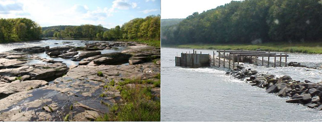
A special kind of strainer called an Eel Weir can be found in the Upper Delaware. Paddle around eel weirs . These are V-shaped wooden and rock walls in the channels, pointing downstream, usually constructed by late summer. Besides catching eels they can also trap and swamp your boat. Watch for the posted signs and avoid them. An Eel Weir is pictured above.
If you do get caught by a strainer, keep calm. Lean to the downstream side, even though that means leaning towards the tree or obstacle. If in a canoe, make sure you coordinate your moves with each other. Don’t try to swim — you could be crushed under the canoe.
BRIDGES
Bridge piers are common collecting points for strainers. Because of the strong current, avoid the piers themselves and give the surrounding area a wide berth, as parts of the piers may extend far under the water. Anticipate your approach from a far distance to stay clear of the piers.