The lower non-tidal Delaware River is the longest and most populated of the three sections, stretching nearly 76 miles from just below the Delaware Water Gap to the tidal waters at Trenton, New Jersey and Morrisville, Pennsylvania.
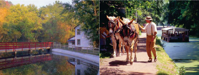
The cultural landscape encompasses a rich tapestry of historic towns and small cities, canals, bridges, factories and farms. There are plenty of opportunities for dining, lodging, and shopping near the river on the Pennsylvania and New Jersey sides. Scenic vistas of rocky bluffs, forested islands, and river banks steeped in history greet recreational users.
Most of the land abutting the Lower Delaware is private property. Please respect private property and refrain from accessing it. Boating and fishing is managed by the New Jersey Marine Police and Pennsylvania Fish and Boat Commission.
Recreational use on the Lower Delaware can be heavy during the summer, especially use by tubers. This section of the river is more densely populated than the Upper and Middle sections, and there are many river access points. Unlike the Middle and Upper sections, the majority of river users are people who live along or near the river.
The Lower Delaware is a popular destination for motorboats of all types. Personal water craft (jet-ski) use is allowed, and its use is extensive. Paddlers need to be aware of other boaters and use caution when running a section of the river that is heavily used by power boaters. These areas tend to be limited to deeper sections of the river that have improved accesses, such as Lambertville, Bulls Island, Upper Black Eddy, and Anters Eddy. Those who desire a tranquil trip through these areas should consider getting out on the water as early as possible on summer weekends, or paddle on weekdays or off-season.
Geologic and scenic vistas include the glorious red shale Nockamixon Cliffs and Milford Bluffs. Significant man-made features include the Delaware & Raritan Canal, Delaware Canal, and Roebling Bridge in Riegelsville. There are other signs of industrial civilization such as quarries, cement and chemical factories, and power generating stations.
Paddling conditions vary greatly, as the Lower Delaware cuts through three physiographic regions — the Great Valley, Highlands, and Piedmont. There are many areas of slow current like the 2-mile-long Upper Black Eddy, but there are also long stretches of gently moving water and riffles, and a few rapids that rival those found in the Upper Delaware, at least in terms of notoriety. Beginners would be wise to avoid these areas unless guided by experienced paddlers.
The water trail ends at the Falls of Trenton, where the river makes its final tumble before meeting the tidal waters entering Delaware Bay.